

The Gift of South Dakota
Subscriptions to South Dakota Magazine make great gifts!
Subscribe today — 1 year (6 issues) is just $29!
The Burnt Hills
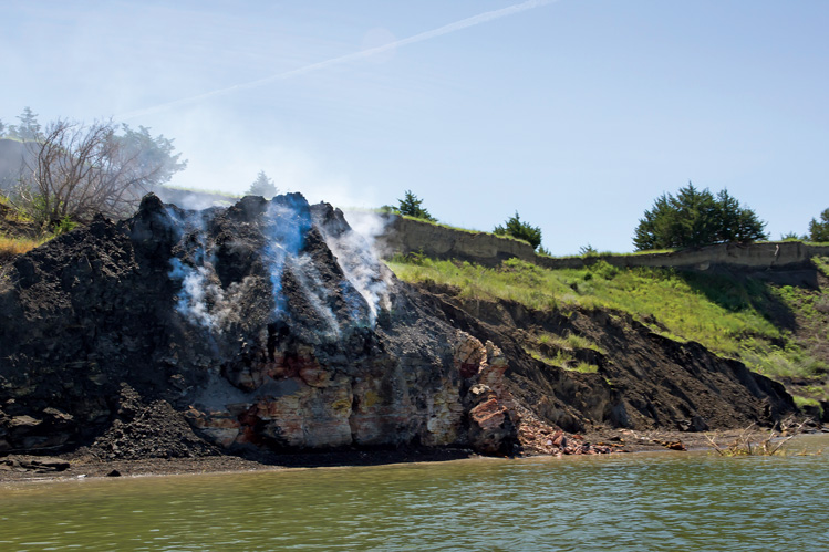 |
| Smoking hills of sulfuric acid emissions can still be found along the Missouri River in south-central South Dakota, but they should be approached with extreme caution. |
In the late 1790s fantastic stories of burning hills and volcanoes on the upper Missouri were often repeated in the small village of St. Louis. Since only a handful of superstitious French voyagers had ever ventured that far up river, speculation was rampant as to what caused hills to burn, or if any such phenomena even existed.
Les Cotes Brulees, French for the Burnt Hills, bordered the west side of the Missouri River in Lyman and Gregory counties and covered an area stretching some 75 river miles from Scalp Creek (10 miles north of Fort Randall) to the mouth of American Crow Creek, (just south of Oacoma) with the heart of the smoldering activity centered at the mouth of White River.
This is an area of dark, gumbo hills with cut banks that drop precipitously to the river. The cut banks expose stratified layers of blackish gray Pierre shale, a petrified mud deposited millions of years ago by a shallow inland sea that once covered the western interior of South Dakota.
Interspersed amidst this 75-mile strip of rolling hills and bluffs are crevices in the earth that once emitted poisonous plumes of sulfuric acid, smoke and steam. Since the landscape features smoke and steam along with many bare shale outcrops that lack vegetation, the early voyageurs might naturally have assumed the charred looking hills had been burned by fires, some of which were still smoldering.
In St. Louis, Lewis and Clark had certainly heard the stories and from their journal entries it is evident that they were most eager to investigate this phenomena. On August 24, 1804, four and a half months out of St. Louis, they got their first look at a smoldering bluff along the Missouri River, about 8 miles below the mouth of the Vermillion River on the Nebraska side.
Clark described the bluff as 180 to 190 feet high noting that "it appeared to have been recently on fire." He reported that the crevice was so hot they could not keep their hands in it. There was no fire or flame Clark reported, just searing heat and acrid fumes.
Captain Lewis, who had apparently remained longer than the rest of the party to make further observations, became ill after returning to the boat. Clark noted in his journal that Lewis was "obliged to take strong medicine to relieve the effects of the fumes."
Scientists later discovered that the fumes Meriwether Lewis had inhaled consisted of sulfuric acid, which in large doses can seriously injure the lungs. The explorers referred to the toxic minerals from this bluff by the generic name of "cobalt" and through deductive reasoning, surmised that it accounted for the stomach disorders that plagued many members of the crew since passing the mouth of the Big Sioux River.
Clark noted that the crew had been in the habit of scooping its drinking water from the surface of the Missouri. However, after their timely discovery of the poisonous "minerals," Lewis ordered the crew to take water from a greater depth and to agitate the water and dispense the foam and scum. The result was that some of their stomach disorders ceased while the boils that had afflicted the men completely disappeared. Lewis’ illness proved to be the key in identifying and alleviating the poisoning of the Corps of Discovery.
This was the only observation of smoldering outcrops that the explorers chronicled in their journals, suggesting that the "fires" in the Burnt Hills farther upstream were dormant that late summer of 1804.
In 1839, 35 years after the Corps of Discovery went up the Missouri, the Burnt Hills were again the subject of intense curiosity and investigation. This time the observer was the eminent 19th century French geographer and geologist Joseph Nicollet, who was able to travel in style, taking advantage of a Missouri River steamboat to make the long, arduous journey north.
Nicollet had been well educated in his native France and was a seasoned explorer, traveler and naturalist. He was also familiar with South Dakota, having only a few years earlier made the first scientific observations of the glacial topography of the rolling hills (Coteau des Prairies) of eastern South Dakota. In fact Nicollet, along with his naturalist assistant, John Fremont (The Pathfinder who would later win fame as a western explorer), had been the first to chisel his initials into the Sioux quartzite at the famous Pipestone Quarry in southwestern Minnesota as a lasting signature of that expedition.
Nicollet, always a keen observer of his surroundings, had begun his study of Les Cotes Brulees long before he saw them. In St. Louis he had chanced to pick up several pumice-like stones he found lying washed up on the levee. He correctly theorized that the stones were formed by an intense combustion process inside the earth and further deduced that this process had dissolved (burned) the substances filling the pores of the pumice stones, transforming them into cinders light enough to float down the Missouri.
"I don't believe volcanoes are the answer," he wrote in his diary, "but I do not intend to lose sight of this phenomenon as we approach the place of its origin.
On June 3, 1839, while hiking near Scalp Butte (north of present Fort Randall), Nicollet got his first good look at the Burnt Hills. In his diary he makes this entry:
"We begin to encounter black or burnt hills as they are called by travelers, thus originating the idea, often contracted, then revived that there are volcanoes in these parts ....
"It seems the subterranean regions of this zone sometime burn due to some reason or other and a thick smoke can be seen rising from the peaks and domes. It is a quiet smoke, there is no flame and it lasts for years. Travelers have indicated where they saw it and these places are easily recognized by the outward signs left by those that most recently burned ....
"When the combustion does go out in these smoldering furnaces provided by nature, the excavations that result from them cause ground depressions and sometimes tremendous cave-ins whence originate these deep trenches and pitfalls that are characteristics of this black zone compared to other parts of the slopes. The heat generated by these smolderings is hardly felt on the surface of the ground. There are not traces of fusion ... or of any thing that might have flowed out of, been projected or carried out (of the ground). The crust of the ground is simply blackened and can no longer entertain any vegetation."
Nicollet later theorized that the smoldering phenomenon was due to the meeting of shale and overlying coal beds that had been ignited by spontaneous combustion or lightning and other means. He gave these smoldering crevices an inaccurate and clumsy name of "pseudo-volcanoes.”
One of the most extensive prehistoric burn areas occurred near the mouth of the White River. Here, within a 5-mile radius, there is evidence of at least five smoldering pits. The red-baked cinder outcrops found here confirm that the pits once burned long and hot. This phenomenon undoubtedly created a sensation among the earliest Indians, beginning first with the Ree and later the Sioux. It probably accounts for the old Sioux name, Manki-Zatah for the White River. Manki-Zatah means Smoke Earth.
Today geologists have ruled out speculation that lightning strikes or prairie fires ignited Nicollet’s pseudo-volcanoes. The best scientific explanation for this phenomena of smoldering pits is based on the fact that some of the shale deposits along the Missouri contain oil, making the rocks carbonaceous and therefore flammable. Some of these rocks also contain sulfide minerals which are known for their spontaneous oxidation and combustion.
The combination of these minerals and their properties results in a complex interaction whereby the sulfides (pyrite and marcasite) interact with oil shale, air, water and possibly bacteria in creating a spontaneous combustion that, as Nicollet and early steamboat pilots noted, can keep these sites smoldering two or three years if conditions are right.
After the pits are fired up the heat in them, while subtle, can become extremely intense. Geologists, using indirect methods of measurement, estimated that interior bum temperatures deep within the crevice can reach a whopping 3,000 degrees Fahrenheit. Temperatures just below the surface of the gas vents can be 760 degrees, or about three times the boiling point of water.
However even these hot, poisonous pits in the earth have a delicate, fragile side to them. Geologists have found tiny, yellow sulfur crystals around the edges of some of the crevices. These crystals are formed near the vents where they precipitate out of the clouds of acrid smoke when it hits the cooler atmosphere.
Lewis and Clark's historic "volcano hill" has now all but disappeared; a victim of nearly 190 years of river flooding and erosion. Most of the other bum areas near the river between Fort Randall and Chamberlain are either extinct or have been dormant for decades waiting for the proper mix of ingredients for activation.
Note: A few burn sites continue to be active on an irregular basis. One of the most recently active areas is near the Platte-Winner bridge both on the east and the west side of the Missouri. In the summer of 2015, one site was easily visible from the bridge looking south on the west side of the river and is best seen from a boat.
For those interested in seeing these sites, maps and other historical information on this area is available at the Snake Creek Recreation Area.
One final word of caution: Burn sites are dangerously unstable when dormant and hellishly hot and noxious when active. They are best viewed from a far safe distance.
Editor’s Note: This story is revised from the November/December 1992 issue of South Dakota Magazine. To order a copy or to subscribe, call (800) 456-5117.


$29 for 1 Year |
 |

Comments