The Gift of South Dakota
Subscriptions to South Dakota Magazine make great gifts!
Subscribe today — 1 year (6 issues) is just $29!
Navigating the Wild Missouri
 |
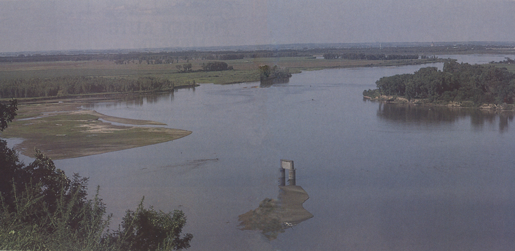
| Although dams are scattered along the upper reaches of the Missouri River, the stretch from Yankton to Ponca, Nebraska remains wild. |
For 53 swirling, twirling miles south of Yankton, the Missouri River still runs wild and free. Navigable waters begin at the bend by Ponca, Nebraska, and continue tamely to the Gulf of Mexico.
Explorers Lewis and Clark and all the other brave souls who traveled the Missouri in the 19th century would best recognize the river today from Yankton to Ponca. Cottonwood trees still line the shoreline and forested creeks wind their way down from hilly grasslands. The same chalkstone bluffs that provided a yellow spectacle to fur traders of yesteryear still stand sentinel to passers-by on the road of water.
Navigating the Missouri was difficult in the 1800s and, at least in that particular stretch, it remains a challenge today. I compare it to an exercise in locating crossings, those areas where the channel crosses from one side of the river to the other. Just as a river snakes down a valley, the channel snakes down the river.
So the art lies in locating the crossings. Probably about 25 crossings lay between the cities of Yankton and Ponca; 25 unavoidable opportunities to ground a big boat.
My river rat friends and I have boated the river on many occasions. So in 1994, when some Floridians bought the Far West riverboat, which had cruised the calmer waters of the Missouri near Yankton as a tourist vessel for several years, they came to us to help them navigate from Yankton to Ponca.
Denny Martens and I thought it would be a challenge and quickly agreed to sign on as guides. Max Brown, a former professional motorboat operator for the Corps of Engineers at Yankton, also came aboard.
The groundings, of course, are what concerned our friends from Englewood, Florida. They were accustomed to sailing such a boat on deep waters — and wise enough to know that the wild Missouri was out of their territory.
Grounding is always troublesome; grounding while down-bound can be catastrophic.
The difference? Bars generally are shaped like sand dunes or snowdrifts; they slant upward to their apex. Once the down-bound rig grounds, its momentum carries it uphill on the bar into shallowing water — and the river's current relentlessly pushes it on. (On a short bar with a low profile, a lucky operator's rig may slide over the bar into deeper water.) Grounding as a hazard is matched by another of the Missouri's infamous hazards: snags — snags in profusion, ranging from twigs to trees, litter the river. The former are of little consequence; the latter may sink a victim. While the steel hull of the Far West was unlikely to be holed, snags were surely a danger to the wooden blades of the paddlewheels as well as to the rudders. Snags and shallows aside, the Missouri harbors many a trap; the grand old stream has a mind of her own and is never to be treated with anything but undiluted respect.
What, then, of the run to Ponca and deep water? A look at some of the truly hazardous passages on the 53-mile run will give the reader a view of running the wild Missouri. From experience, we identified three truly treacherous crossings between Yankton and Ponca. Down bound, in order, lay the upper reaches of the Audubon Bend, the turbulent, severely eroding North Alabama Bend and the infamous Elk Point Bend, just above Ponca's channelized river. The Far West's passage through these potential traps was our main focus.
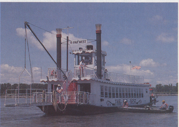
The Far West eased away from Yankton's Riverside Park near Mile 806 on June 25 to begin her 2,500-mile run to Florida. One of the Vermillion river rats was stationed in the pilot house, the other ahead in an outboard-powered 15-footer. Three passengers, observers and potential pushers were aboard in addition to one of the Vermillion river rats and the Floridians. The day was clear and bright, the wind light. A fine cruising day though it were, the Missouri soon reminded the voyagers that running the Missouri with a craft of this size was a chancy undertaking. Midway down the Yankton Reach an invisible, deep-lying snag raked the Far West's bottom, jolting and tilting her to one side. No damage was ascertainable, and the run proceeded on east, the channel more or less hugging the Nebraska shore. Running slowly and cautiously, the Far West slipped effortlessly downstream, her crew developing a feel for the craft and the river. The day was perfect for running, and the handsome Far West was a spectacular sight on the storied Missouri. An uneventful run through Jacques Bend and the braided St. Helena Bend led to one of the Missouri's most spectacular sights — the delightful Audubon Bend, Mile 787, west of Vermillion. Here, precipitous bluffs of exposed shale and chalk, capped by a layer of darker loess, rise abruptly above the river. Oak trees cloak the bluffs, while Bow Creek laps their base as its waters languorously merge with the Missouri's.
 |
| The day was clear and bright as the Far West eased away from Yankton’s Riverside Park bound for Florida. With help from local river rats and a dollop of good luck, the Far West made its way through seen and unseen snags and sandbars. After Ponca, the crew faced a clear run down the Mississippi to the Gulf. |
Shunted eastward by the unyielding bluffs, the Missouri sweeps down the 7-mile-long Sandhill Reach, one of the longest relatively straight reaches on the river. (The longest is the 16-mile Steamboat Reach, near Pierre.) Here, at Mile 785R, the Far West tied up for the night. With some 32 miles to go and the most hazardous crossings yet to be traversed, caution dictated a stop while the day's experience was evaluated and the plan for the remainder of the voyage was reviewed. The Far West's presence brought people streaming to see the largest sternwheeler to sail this area for decades.
Sunday, June 26, was bright and clear, with a light to moderate northwest wind; a beautiful summer day. Ominously, the river had fallen during the night, a fact starkly announced by the glistening patches of wet bar exposed by the falling river, as well as by a dark, wetted band of shoreline at the water's edge. The 2-inch or so drop could well be the cause of real problems. Bottom clearance on the Missouri is as often measured in inches as in feel. Encouraged by the ease and success of the previous day's run, well aware of the cost of delay and now possessed of a better understanding as to how to run this river, the owner said, "Go."
Aided now by a pair of knowledgeable river rats from Ponca — Bill Conrad and Tim Armstrong (accompanied by a yellow lab named Oatmeal) — the Far West resumed her search for salt water. Crossing to the Dakota shore near the east tip of Goat Island, she skirted the watery grave of the Missouri River Queen, a private ferry that fell victim to the river some two months earlier. Other than an area of turbulence on the Missouri's surface, there was no sign of the sunken 12-ton Queen. Paddling steadily down the Clay County Park Chute, the skipper acknowledged an assemblage of startled onlookers with a blast of the horn.
Ahead lay the oddly configured crossing at the North Alabama Bend and all attention was focused on that fearsome obstacle. At the outlet of the park chute the Missouri graphically displays one of its seemingly perverse characteristics: it spreads and shallows. The deep, chute-confined waters, which had provided a good, easily seen channel, now fan outward, slowing as the bottom drag increases, and endlessly precipitate much of their sandy load. The neat, comfortably deep channel quickly disappears, replaced by a perplexing maze of shallows, bars and stranded snags. The precipitated sand almost always diverts the spreading waters; the "hose" of the channel becomes the "spray" of a sprinkler. (One could say the waters have been "un-funneled.")
A crossing is mandated by the delta-like accumulation of sand below the outlet of the park chute. In effect, the river dams its own channel and must then find a way around its own handiwork. The lead boat crept through the braided waters, "dip sticking" constantly to determine if the channel (if it can be so described) still flowed as expected. At one point the crossing's channel actually curved upstream a bit before being diverted sharply downstream by a submerged bar. The lead boat found an "iffy" 3 feet of water, and the Far West, running as slowly as the need for steerage would permit, crept through the shoal-speckled crossing, the wind and current combining to force her into a crabbing configuration as she fought to follow the slight upstream curvature of the channel.
The tortuous crossing completed, the Far West made a hard left turn as she warily traversed the North Alabama Bend. Immediately she encountered another of the Missouri's infamous array of snags. On the inner aspect of the bend, the Missouri in recent years has eaten well over a quarter of a mile south into the Nebraska bottomlands, devouring many acres of huge cottonwoods and a country schoolhouse. The remnants litter the river below the cut; the schoolhouse was broken up and only an occasional bit of siding can be found. The cottonwoods often lie where they fell, creating an awesome tangle of massive snags. The Missouri continues its savage assault on the sandy banks, and the sand-laden waters froth as they surge by the bottom-trapped snags. Trees thus snagged are usually trained in the direction of the river's flow, an advantage for the down-bound craft since, rather than being impaled, it is likely to ride onto and over such snags should one be hit. Occasionally a limber snag will seesaw in the turbulent current: these are the "now-you-see-them-now-you-don't" sawyers dreaded by the wooden-hulled steamboat captains.
Assiduously tracking the lead boat, the Far West avoided the snags, both the seen and unseen, her crew hoping no deep-lying snag would spear the hull, splinter a paddlewheel blade or shear off a rudder. Emerging from the successful negotiation of this snag field, a course was set into the pooled river above the pinch at Mulberry Bend. Some weeks earlier an up bound towboat and barge grounded in these shallows, spending a day or so struggling to freedom. The Far West did not ground here, but a wake of sandy water graphically underscored just how limited the depth was.
Deeper water and good running lay below the bend, and the Far West methodically swept on down the liquid slope. Crossing to the Nebraska shore at the mouth of the Vermillion, we travelers viewed the shoreline erosion caused by the massive jet of floodwater spurting from the Vermillion during the 1993 flood. The Vermillion's waters, then 50-feet deep at the mouth, swept the Missouri's waters aside and slammed headlong into the sandy Nebraska shore. The landowner claims a loss of some 100 acres.
Clearing the newly cut Curry Chute, then easing through the Ionia Bend, the Far West proceeded on, slowing as she approached the long infamous Elk Point Bend. This bend, lying just above the navigation channel at Ponca, is a sprawling, braided, perplexing confusion of low bars and flat water. Here, within sight of Ponca State Park and deep water, lay the Far West's major obstacle on the run to Ponca. Slowing as much as she could without turning upstream, the pilot awaited word from the lead boat. A scattering of pleasure boats was clustered nearby, attracted by news of the unusual traveler. Later it was learned most of the viewers expected to find the Far West hard aground, well upstream. The betting was she couldn't make it to Ponca.
Two hundred yards ahead, a highly visible crescent-shaped reef line marked the downstream edge of a submerged bar. To either side lay bars exposed or barely awash. There being no way around the reef, it was necessary to cross it. The outlook didn't appear promising. The lead boat, moving slowly, dip sticked what appeared to be the deepest route. Seeking the likeliest route over the bar, the dip sticker scanned the surface for clues as to the depth. What to look for? Sand-laden water, small, up-welling boils, a faint break or irregularity in the ripple delineating the reef line — features a novice would likely never heed. A combination of reading the river, "dip sticking," and river sense — plus a welcome dollop of good luck — lay back of the successful search for adequate water. At the reef line, dip sticking revealed about 40 inches of water; the Far West's draft was 36. This pass — really only an indentation — in the reef appeared wide enough to admit the oncoming Far West, and the signal to come on through was made.
Proceeding as slowly as she could without reversing her paddlewheels, the Far West aimed for the designated pass in the reef. Moving with the current, her rudders had little bite and the paddlewheels were of little value in steering; essentially she was coasting. The Far West’s windage presented a defenseless target for the northwest wind, and the craft was nudged to her right. This resulted in her almost missing the pass. Her forward third cleared the reef line, but the rearward portion of the hull gently grounded on the submerged bar. Slowly the Far West slid to a halt. Fortunately, she grounded with part of her hull again in deep water, and the Missouri sluicing by the hull soon washed her on over the bar, aided by the flailing paddlewheels — and a most helpful push by the lead boat. Pushing the stern a bit to the right exposed more of the hull to the current and the wind, helping the Far West to slide off the bar to continue her run. Subsequent investigation of the entire Elk Point Bend by the Vermillion river rats revealed that there was then no really deep channel through the bend; the river simply spreads out and filters through a maze of bars chaotically interspersed in a sprawling sheet of shallow water.
Once free of the sandy grip of the bar, a short crossing in good water put the Far West into 20-foot depths hard along the Dakota shore, now heading south to Ponca, Mile 753. Deep water — and a clear run to Florida! Sunday throngs at the Ponca State Park swarmed to ogle the unannounced visitor. No sternwheeler of this size had docked at Ponca since a visit by the Corps' Patrick Gass in 1936. What a sight under the chalk bluff!
With a navigable channel now at hand, the need for the Vermillion river rats ceased, and we took leave of our charge to start the hill climb to our base at Black Acre on the Sandhill Reach, 30 miles upriver. The Far West did not tarry long at Ponca. With the Ponca river rats (and Oatmeal) aboard, she ran downriver to South Sioux City where she overnighted near the Marina Inn.
The running time from Yankton to Ponca State Park was about eight hours; the river mileage 53 and the speed down the wild river averaged some seven miles an hour (the current is about four miles per hour.) Other than a bit of a tipping by an unseen snag on the Yankton Reach and the skidding over the bar above Ponca, the run was pretty much uneventful. Thirty-one days after leaving Yankton the Far West reached her new homeport at Englewood, Florida. (Near St. Charles, Missouri, she passed near the site where her namesake, Capt. Grant Marsh's Far West, sank, some years after he brought the news — and the survivors — of the Little Bighorn battle to Bismarck.) Heavy rain closed the Tenn-Tom Waterway, so the Far West ran the Mississippi to the Gulf. Now in salt water, she ran the Intercoastal Waterway where possible. Her luck held, enabling her open gulf run to be made in calm seas without incident. With dry-docking for a repainting, a remodeling for her new role and a change of name, the Lantern Queen served as a dinner boat in the Englewood area.
Somehow, it seems a craft that bore a legendary name and herself mastered the Mighty Mo deserved a better fate.
About the author: Jim Peterson has lived along the Missouri River all his life. He taught business at the University of South Dakota and is now retired in Vermillion.
Editor’s Note: This story is revised from the May/June 1996 issue of South Dakota Magazine. To order a copy or to subscribe, call (800) 456-5117.


Comments
Anyway, that's the story of the Far West/Lantern Queen to date.