

The Gift of South Dakota
Subscriptions to South Dakota Magazine make great gifts!
Subscribe today — 1 year (6 issues) is just $29!

Peninsula Paradise
Mar 3, 2021
Growing up in Chicago, my youthful idea of a pastoral Shangri-la was straight out of the old children's book Heidi, and maybe Lassie flicks on WGN.
Heidi was a German Swiss girl who spent her days skipping though the emerald valleys of the Swiss Alps in a dirndl, herding goats, reading Bible stories and warming the heart of her disgruntled adoptive grandfather, Alm-Uncle. Eventually she teaches a disabled girl to walk again through a kind of miraculous ecotherapy (Heidi was ahead of her time for a country girl).
Heidi the healer closes the chasms between human and God/Nature that debilitate us mentally (Alm-Uncle) or physically (Clara). When you feel like “the mountains are calling” you, Heidi is that iPhone.
Now as a South Dakotan, I field those calls. I go hiking through the Black Hills, Badlands and northwestern butte country, or paddling down the Missouri or Cheyenne.
Each of those places is curative. The South Dakota country that rekindles my city boy concept of the Dorfli foothills where Heidi skips be-dirndled through a sea of green is on the peninsula that lurches out like a velvet mullein stalk into the Little Bend of the Missouri River.
True, it's a pricklier, snakier green sea. Skipping barefoot might be a bad idea. Instead of snowy peaks, the meadows are enveloped in azure water and sky. The river bluffs bubble through beneath your feet. Each billowy detour off the main appendage is a fuzzy green caterpillar bulging in segments as it munches the Missouri. To stand on a hill and trace each bulbous ramble into the blue, or the flower parades through the folds that empty into shallow pools at water's edge, may be as medicinal a psychic skip in the shadow of the Swiss mountain Stanserhorn.
You can access this peninsular Xanadu at the Little Bend Recreation Area. At a point where the road curves southwest down to a boat/fishing pier, there's a small parking area with a sign that indicates walk-in only. From here you'll leave the state recreation area, though the entire peninsula is a public land, state and federal (Army Corps of Engineers). My guess is that very few non-hunters ever hike here.
I set out to explore the fingerlings and make it to the V-shaped inlet at the center of the terminus. With an evening start, I hiked along the trail that cuts a straight-ish line along the northeast edge until it faded away about a mile and a half in. From there I spotted a picturesque sub-isthmus — snaking out to a cliff surrounded by a narrow strip of beach — enclosing a cottonwood leaf bay.
In about 4 1/2 miles, I reached the river side and pitched tent on a narrow strip of beach. Bullfrogs and great-horned owls sang a dirge for the day. A garter snake slithered along the edge of the water, mirroring the rippling moonlight.
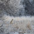
At dawn, I packed up and kept my eyes on the big water to reach the V. Throngs of grasshoppers hurdled ahead of me, many caught in the webs of ferocious-looking yellow garden spiders. Wildflowers hewed close to the coulees. A velvety-antlered buck Heidi-ed his way through the verdure. As the land tapered in the final descent there were swan-feather fields of foxtail and other hairy grasses.
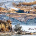
Then it was there — the pool that softens the point of the V. Jade swells surround, here and there sheered down to Pierre shale, cobalt above and below. Gulls perched on a narrow sand bar. I lingered a bit and began the way back, up the spine of the main stalk where you can see every caterpillary appendage burrow into the blue.
Michael Zimny is a content producer for South Dakota Public Broadcasting and is based in Rapid City. He blogs for SDPB and contributes columns to the South Dakota Magazine website.


Comments