The Gift of South Dakota
Subscriptions to South Dakota Magazine make great gifts!
Subscribe today — 1 year (6 issues) is just $29!
A Lost Monument
Apr 5, 2017
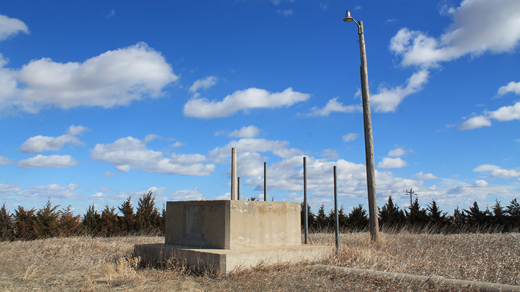 |
| A concrete slab on Snake Butte near Pierre once supported a monument declaring that spot the geographical center of North America. |
There's a humble concrete slab on Snake Butte, about 4 miles north of Pierre. This solitary relic amid the grass was once the foundation of a monument to the capital's nearly forgotten title of "approximate geographical center of North America." Today, it’s a just crumbling slab on a remote hill.
Pierre long ago conceded the designation. A counter-claim by Rugby, North Dakota, the elements, possibly even vandals, worked together to wear down our state capital's resolve to maintain a marker.
Robert F. Kerr, a professor at the South Dakota State College of Agriculture and Mechanic Arts (now SDSU), first made the Pierre-as-continental-center designation in 1904. Kerr drew lines from opposite corners of maps of South Dakota and North America and found that, for both, they intersected at Pierre. In 1911, Willis Johnson — geographer and president of Northern Normal and Industrial School (now Northern State) — employed a similar method to derive the same result in his book South Dakota: A Republic of Friends.
As the pre-eminent Pierre booster, developer Charles Hyde — who built many of the turn-of-the-century buildings still standing in Pierre — saw the center designation as useful to his cause of promoting Pierre as a city on the rise.
“He kind of took this idea and ran with it a little bit,” says geographer Jerry Penry, a Nebraska-based surveyor who has written extensively about geographical center monuments.
Hyde got together with state historian Doane Robinson and the two decided to place a monument a few miles north of Pierre. In 1923, a 23-foot-tall concrete obelisk was placed in the middle of the road between two lanes of Highway 14. A bronze plaque embedded in the base of the monument read: "Center of South Dakota and Approximate Center of North America."
Shortly after, it was determined that, as Hyde wrote in his 1939 biography, Pioneer Days, “any obstruction built into the center of a highway becomes somewhat of a menace to safety.” A new, similar monument was built atop nearby Snake Butte in 1928. A fence was built around the new monument to protect it, leading to some speculation that the prior incarnation may have been vandalized. In later pictures, it appears that the fence had been removed.
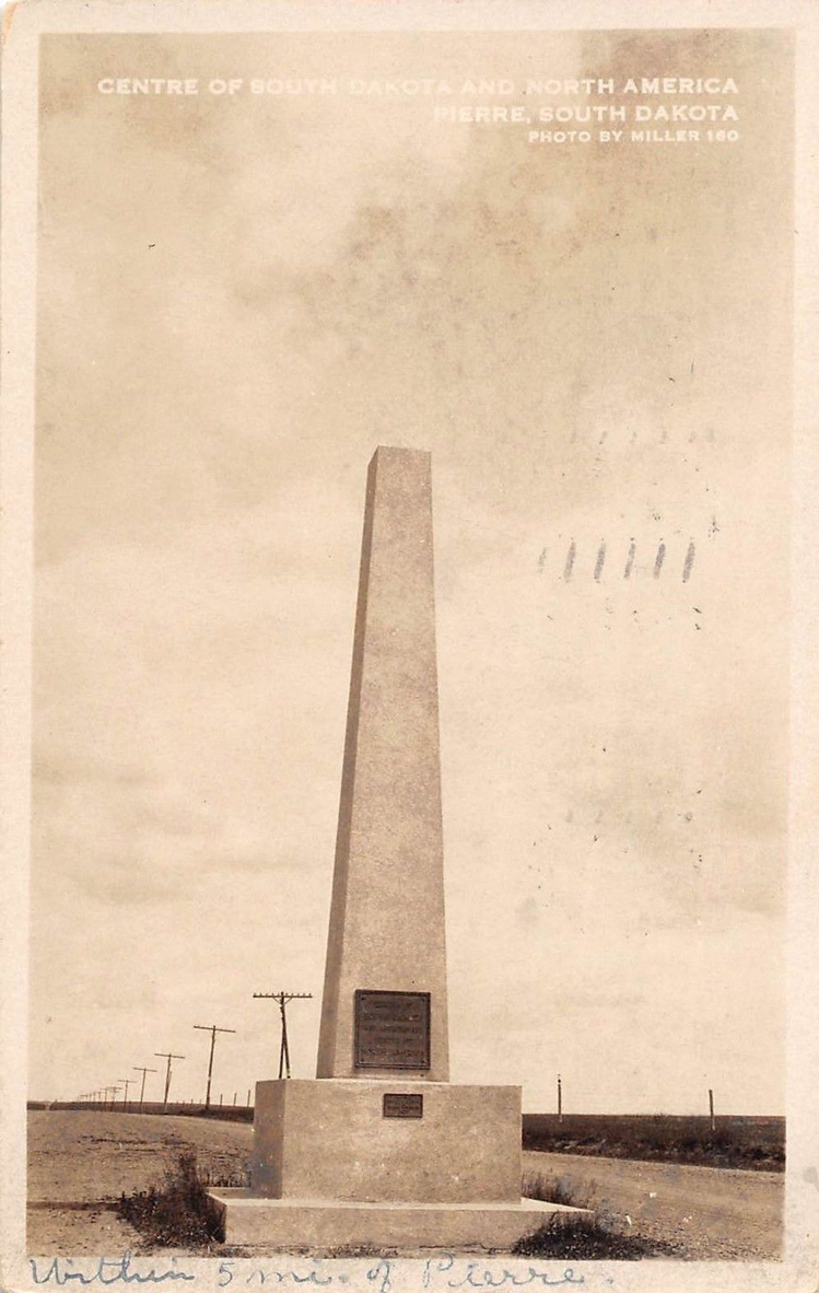 |
| Charles Hyde and Doane Robinson helped place this monument marking the center of South Dakota and North America between two lanes of Highway 14 in 1923. |
The first challenge to Pierre’s geographical center claim originated from a formidably official source. In 1930, the U.S. Geological Survey’s Bulletin 817 designated the center of North America at a point about 18 miles north of Rugby in Pierce County, North Dakota.
Rugby was the county seat, and the townspeople swiftly decided to put the designation to use to attract curious travelers.
Pierre noticed. But, emboldened by a proclamation from the federal government, at least some of Rugby’s civically engaged citizens felt their claim was more legitimate, and said so.
Even though the Pierre monument only claimed to be the “Approximate Center of North America,” and Rugby was itself a small distance from the site designated by the USGS, the dispute over which town was closer to center occasionally flared up in the papers.
Doane Robinson immediately took up the case, asking the USGS, “for the method by which the center was definitely fixed at Rugby."
USGS Secretary W.C. Mendenhall replied that, "There is no way known to determine the exact geographic center, mathematically; they are only approximate in varying degrees. The position referred to in Bulletin 817 is only approximate.”
The people of Rugby built their own stone-cairn center monument in 1932, and the town attained, through due process, a patent on the claim “Geographical Center of North America." Rumors about more nefarious actions by Rugby boosters have long festered but never been proven.
State historians on opposite sides continued the fight well into the 1940s with North Dakota’s Will Reid writing that, “There appears to be no basis for the placing of [the Pierre] marker… it should be removed.” South Dakota state historian Will Robinson (son of Doane) again insisted that the Pierre monument marked an “approximate center.”
When relatives of the great Hunkpapa Lakota chief Sitting Bull, in cooperation with South Dakota state historians, planned to exhume his grave in Fort Yates, North Dakota — and re-bury him at his present memorial site overlooking the Missouri river near Mobridge in 1953 — the Bismarck Tribune bitterly recalled the center dispute, warning readers to, “Tie down your oil wells, gentlemen, rustlers are coming.”
Maybe fears of sabotage on either side stemmed from a mutually uneasy sense that neither claim had a solid geographical footing. Neither of the methods employed in determining the competing towns as geographical centers — drawing diagonal lines from opposite corners of a map (Pierre), or a more complex method involving a cut-out North America model suspended by cords tied to a common center (Rugby) — are scientifically sound, says Penry, who is working on a book on geographical centers.
Even if they were, there's still the question of how to define North America. “No two people would ever come up with the same map of North America,” says Penry. “In particular in the Northern region where you have water areas and islands.” Without a consensus on continental boundaries, there can be none on where the center lies.
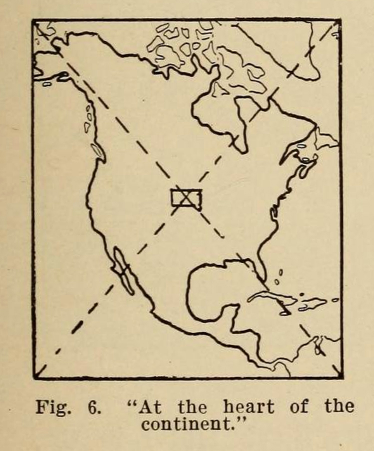 |
| South Dakota geographers Robert Kerr and Willis Johnson found the center of North America by drawing lines from opposite corners of maps. This illustration appeared in Johnson's book, South Dakota: A Republic of Friends. |
Photos from the 1950s show significant deterioration to the obelisk on Snake Butte. By 1958, the monument was gone. The Huron Daily Plainsman reported that, “a new modern marker has been erected to replace the concrete monolith.” The write-up mentioned, “an irate group of North Dakotans were among those that found fault with the approximation and claimed that the center of North America was near Rugby, N.D.”
The sign that replaced the obelisk — erected by Charles Lee Hyde and Will Robinson, sons of the original monument builders — was a bronze historical marker like those still seen today at points of interest across South Dakota, on a concrete pole atop the surviving pedestal. The sign blamed the cause of the monument's deterioration on "poor materials."
The tactile text was also up front about the fact that the center designation was only an approximation, stating that the true continental center "was neither at Rugby nor near Pierre," and that, "until some divine authority determines a better method, we will continue to call this the approximate center, but will quarrel with no other approximations.” The installation of this marker and its controversial message began a new era on Snake Butte. The monolith, though it may have been shoddily constructed, lasted 30 years. Markers wouldn't last that long any more.
The Mitchell Daily Republic reported in August 1959 that the sign — missing since July of that year — was found by rancher Oliver McGruder “while mowing hay in a field about 200 yards from the monument.” If the marker was ever remounted, it’s no longer there.
In 1988, the Pierre Capital Journal reported that a replica of the bronze plaque embedded in the base of the monument was installed to replace the original, which had been stolen one year prior. The article quotes state Centennial Director Jim Larson saying that an unnamed “gentleman in Rugby, North Dakota has taken offense that the monument even exists,” and that, “North Dakota attorneys have contacted South Dakota attorneys.” The replacement plaque has since gone missing.
During the state’s centennial celebration in 1989, a new sign with the words “South Dakota’s Centennial Acre” was placed above the base. That also disappeared.
“Somebody was doing anything they could to erase any inclination that Pierre was also at the center of North America,” says Penry. “It became a big challenge for them to keep anything up.”
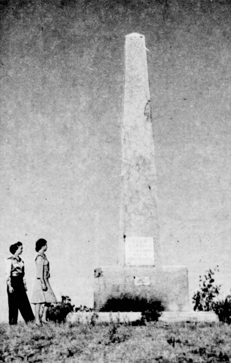 |
| This photo from 1947 shows the monument atop Snake Butte. |
Was a posse of marker-rustling geographic vigilantes wearing down Pierre’s determination to stake a claim as approximate center? Antagonists on either side of the divide had warned that their adversaries might harbor a rogue element. Rugby’s 1932 monument stands. The town recently gave it a $5,000 facelift. Pierre can’t seem to find a fastener sturdy enough to hold anything down.
“There’s no documented proof of anybody ever being caught in the act,” says Penry. Maybe Pierre just has bad luck with center monuments. Maybe there are other forces at work on Snake Butte. Correspondence by Doane Robinson, circa 1923, shows that he once had plans for a separate monument on Snake Butte — a bronze plaque, affixed to a boulder, inscribed: “Sioux tradition that monster serpent, (perhaps a cyclone) leaped out from this butte and devoured an entire village.”
Rugby’s long streak of better fortune recently hit a snag of its own. After 84 years of holding the title, last year Rugby’s citizens were jolted by the unwelcome news that bar owner Bill Bender of Robinson, North Dakota (about 98 miles south of Rugby) had applied for, and received, the patent for the title “Geographical Center of North America” — not for the town of Robinson, but for his bar, Hanson’s.
Rugby had failed to renew the patent with the United States Patent and Trademark Office when it expired in 2009. “It had sort of slipped between the cracks, I think, at the Chamber of Commerce office,” says Cathy Jelsing, director of the Prairie Village Museum at the Geographical Center of North America. “There was surprise and disbelief that someone else would try and scoop that up and take it away from us.”
The Pierce County Tribune recently reported that the Rugby Chamber has contacted Bender and his co-owners, “requesting they cease all use of the mark and surrender their federal registration,” and that the Chamber may consider challenging the patent, based on the concept of common law trademark rights — rights developed through use rather than statute.
At Hanson’s, a large decal affixed to the floor proclaims geographical center status for the bar. Bender acknowledges receiving a letter from the Chamber, but is enjoying the notoriety.
“We sold out of bar T-shirts right away after the Wall Street Journal article hit,” he says. “Last fall we had bikers and lots of people altering trips to swing up and stop at the bar. We expect to have a lot more interest leading up to Center Fest.” (He’s putting on the first annual Center Fest this August.)
“We’ve already had lots of bands contact us about playing. Hopefully we’ll have our new monument made by then, so we can do that unveiling, and it’s in the planning stages now but we’re working on a giant trebuchet.”
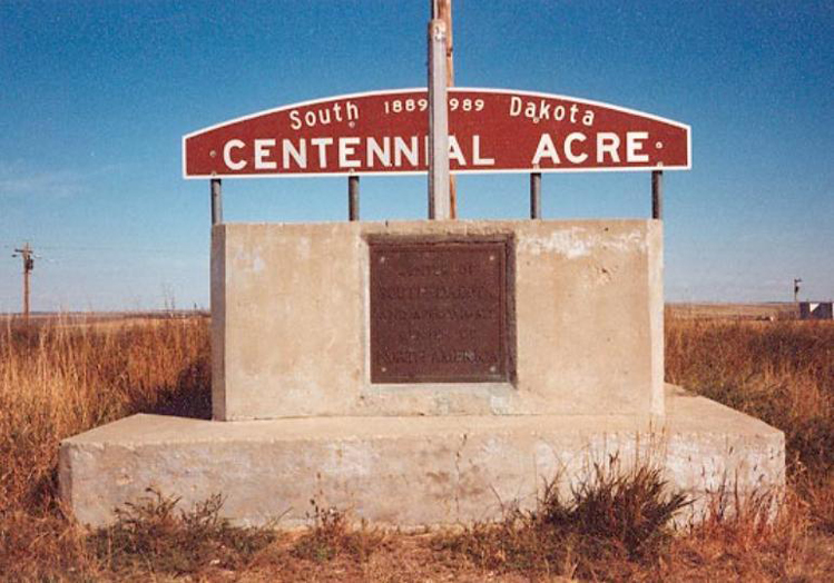 |
| In a string of thievery, this sign placed at the monument site in 1989 was soon stolen. |
He isn’t worried about retaliation. “Our monument [will be] right in the center of our small town. Nothing really goes on in our town without people seeing it or knowing about it.”
Meanwhile, just this year a new claim emerged. Peter Rogerson, a geography professor at the University of Buffalo, used a mathematical method he developed for determining geographical centers to pinpoint a new center of North America at Center, North Dakota.
“Needless to say I was very surprised,” says Rogerson. “To think that it had been named Center because it was the center of the county, and then to find that it is also the center of the continent was an incredible coincidence.”
Rogerson’s method utilizes azimuthal equidistant projection of boundary points, and “minimizes the sum of squared great circle distances from all points in the region to the center.”
“It’s not hard to argue,” science writer Steph Yin writes in The New York Times, “that Dr. Rogerson’s claim is more precise than Rugby’s and Mr. Bender’s.”
While Rogerson’s method is more scientifically sound, there’s still the issue of a consensus (or lack thereof) on continental boundaries. “The boundary of North America was defined by using a U.S. Geological Survey ‘Boundary File,’” says Rogerson, “that contained the mainland portion of the continent — from Panama up to northern Canada — but not including the islands in the far Canadian north, other islands off the coast, and not including Greenland, which some people include in the definition of North America.”
Center Mayor Harold Wilkens says the town doesn’t have any current plans to capitalize on the designation. “This isn’t a definite deal,” he says. "The New York Times is where it started from. A lot people have said they [the Times] like to stir up problems. I don’t know if this is true or not.”
If, as Penry has written, “the outline of North America and what should or should not be included when defining the northern regions of the continent can be left to many interpretations,” and “therefore, the monument at Pierre, in reality had just as a legitimate claim as anywhere else,” then maybe Rugby’s, Hanson’s and Center’s claims are co-equal. To the extent that a designated continental center exists at all in the popular imagination, that place would probably still be Rugby. For now anyway, but should Rogerson’s designation receive some organizational imprimatur, or Hanson’s Bar sell a few hundred more T-shirts, that could change.
Nobody knows for certain what happened to Pierre's post-monument markers though, and even if decades ago there was a crew of center-hogging hooligans clandestinely operating out of Rugby, in the end their labors were undone by a couple emails. Tenaciously as they may have tried to hold onto the center, as Yeats observed, the center cannot hold.
Rugby’s loss is something Pierre should understand acutely. If being first mattered more than the method, the patent, the monument, then Pierre would still hold the title. Sometimes in a certain time and place, “approximate” is close enough to center. In 1923 it was, and maybe that comes back around.
Back in Rugby: “I think people have calmed down now,” says Jelsing, “and they figure that we’ve had a monument since 1932, and we’re not going to let go of this title.”
Pierre doesn’t have to either.
Michael Zimny is the social media engagement specialist for South Dakota Public Broadcasting in Vermillion. He blogs for SDPB and contributes arts columns to the South Dakota Magazine website.






Comments