

The Gift of South Dakota
Subscriptions to South Dakota Magazine make great gifts!
Subscribe today — 1 year (6 issues) is just $29!
The Thrill of the Chase
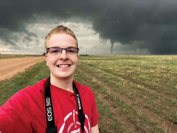 |
| Watertown's Alex Resel is happiest chasing storms across South Dakota. |
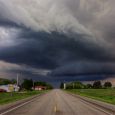
Alex Resel’s passions are photography and severe weather, and they intertwine perfectly from late spring to early fall. Though he is only three years out of college, the Watertown storm chaser has already driven tens of thousands of miles in pursuit of thunderstorms, tornadoes, derechos and all manner of nasty weather, returning with beautiful photographs that often belie the dangers.
He’s quickly learned the ins and outs of chasing, such as what to look for on radar and where to safely position himself, but it wasn’t that long ago that his interests in storms and photography were just blossoming. On a humid Father’s Day in 2012, storms rolled into Watertown, bringing heavy hail and setting off the city’s tornado sirens. “Until that point, I had no interest in weather, but something clicked after that storm,” says Resel, who was 12 at the time. “From there, I would draw maps of South Dakota and look at the local weather forecast and do my own weather map forecasting.”
His first “chase” came three years later, when his dad drove him 30 miles north to Summit after seeing a forecast from the National Weather Service’s Aberdeen bureau. Storms were set to fire northwest of the little Roberts County town. “We sat there for probably an hour, just watching them move in. Eventually they merged into a line and drifted toward Watertown.”
Any photos taken that day were captured with a smartphone, but in 2016 he got his first digital camera. He spent the next few years practicing landscape and storm photography and earned a business degree with an emphasis in photography and media from Lake Area Technical College in 2021.
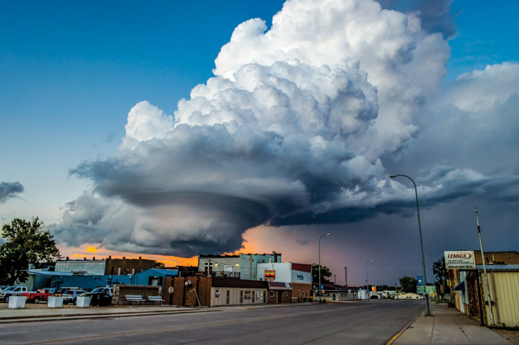 |
| A supercell over Clark. |
Resel launched Outer Shots Photography, where he offers prints of landscapes, the Northern lights and the severe weather that he’s been chasing in earnest since the summer of 2020. The makings for strong storms were present west of the Missouri River on June 6, so he headed to the Badlands on his first solo chase.
“It looked like a couple cells could fire, but it didn’t happen because of an ingredient called cap, which prevents storms from growing,” he says. “It’s like putting a lid on a boiling pot of water. I thought the day was over, so I went to the Badlands to hike around for a couple hours and then head home. But I noticed dark clouds were coming in from the south and west, so I decided to wait and see what was going on. A big line of storms started moving in from Nebraska and Wyoming. It developed a beautiful shelf cloud and packed a lot of winds. I watched it move in from one of the overlooks. I was looking south, and as the line was moving overhead a tornado formed right in front of me in the Badlands. That was my first tornado, and it was a really cool thing to see.”
Resel plans his routes based on weather models and utilizes a weather app on his phone, which stays mounted to his windshield. “I’m looking for moisture, instability, lift and shear,” he says. “If all of those ingredients are in place, it’s usually a good sign that you’re going to get some organized severe storms. If multiple storm cells are firing at the same time, I look at which one is the tallest. Usually that’s going to be the dominant storm. Hopefully I’ve picked the right storm so I can get the shots I need.”
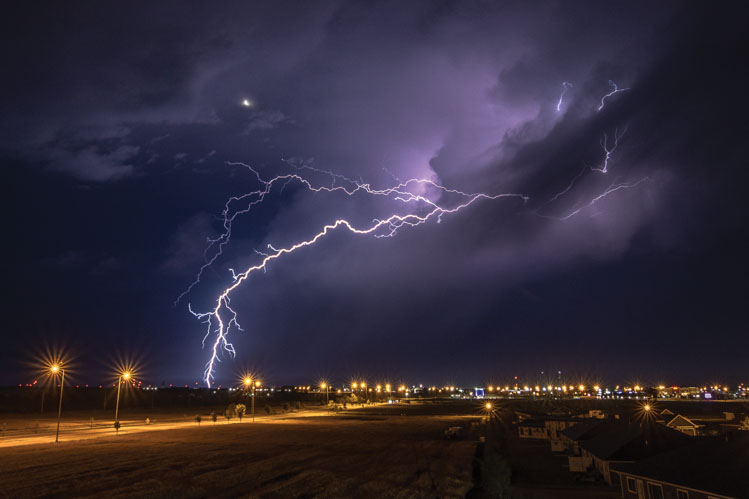 |
| A lightning storm over Watertown. |
That doesn’t always happen. South Dakotans likely remember where they were on May 12, 2022, the day an unusual and violent derecho raced across the state at 50 to 70 mph, packing straight line winds of 60 to 100 mph, the equivalent of a Category 1 hurricane. Resel noticed a localized enhanced tornado risk forming near Redfield, so he headed to Spink County. “Big cumulus clouds started to form, which is a good sign that storm activity is brewing, but as soon as they bloomed the derecho moved through and they disappeared. We didn’t get any storms to mature.” At the same time, he heard concerning reports closer to Watertown, including the tornado that caused extensive damage in Castlewood. “It’s a scary feeling being away from home and not knowing what’s going on.”
To help assuage those same feelings in others, he regularly reports what he sees to the National Weather Service, either by calling an office directly or through social media. Chasing severe weather can provide an adrenaline rush unequalled in other endeavors, but chasers are generally not simply reckless thrill seekers. There’s an important public service component to their work.
Peter Rogers, the warning coordination meteorologist with the National Weather Service’s Sioux Falls bureau, says information received from storm chasers and spotters can be crucial. “We have a lot of complex technology at our fingertips that helps us determine what’s going on, the radar probably being the most important,” Rogers says. “But there are still limitations to that, and there’s nothing better than having eyes and ears on ground watching what’s happening. From the Weather Service perspective, it’s all about the protection of life and property, and all the information that comes from chasers and other spotters is critical information to accomplish that mission.”
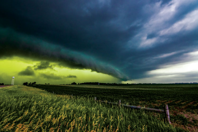 |
| Storms that moved from Huron into northwest Iowa in the summer of 2022 turned the skies near Sioux Falls an eerie green. "It was the meanest looking storm I've ever seen," Resel said. |
Resel attends the NWS’s yearly severe weather awareness classes, which are offered in the spring. Meteorologists begin with basic terminology, such as the differences between watches and warnings, and then discuss weather in more detail, including how to identify supercell thunderstorms that could produce tornadoes and multicell storms that can cause other hazards. The classes emphasize safety, but Resel also uses the information to help identify the best position for photographing storms. “You’ve got to be on the southeast side of a storm. That’s where you get updraft and it’s where the photogenic parts of the storm are. That also keeps you safe from a tornado or large hail.”
Dangerous situations can still arise. Resel was in a caravan of storm chasers following severe weather in Colorado in August of 2023 when a tornado developed. “It wasn’t on the ground yet, so I felt comfortable, and I knew where to go to get out of its path. As the backside of those tornadic winds wrapped around it picked up rocks and broke out my back windshield. That ended my chase. I did get to see the tornado develop in front of me, but I got out of there as soon as I could to prevent any further damage. That was my first mistake in storm chasing, but luckily it only cost me a back windshield.”
Moments like that are learning opportunities, and not likely to quell the excitement that comes from storm chasing. “Watching the atmosphere work its magic and to have that unfold right in front of you is an amazing experience,” Resel says. “It’s not one that many people know. Each time is different, but you get those same feelings.”
Looking at his photos, you can almost feel it, too.
Editor’s Note: This story is revised from the May/June 2024 issue of South Dakota Magazine. To order a copy or to subscribe, call (800) 456-5117.


$29 for 1 Year |
 |

Comments