

The Gift of South Dakota
Subscriptions to South Dakota Magazine make great gifts!
Subscribe today — 1 year (6 issues) is just $29!
The Yankton to Marty Trail
 |
| South Dakota Magazine intern Ava Brandt met Digger at Mensch's Greenhouse in Avon. |
A golden dog named Digger met us at the door of Mensch’s Greenhouse, his tail wagging like a windshield wiper. Two cats lolled on a flower worktable and a dozen colorful cockatiels chirped from two cages near the petunias.
Any traveler will crack a smile at Mensch’s Greenhouse in Avon — and that’s fortunate because for the most part this Yankton-to-Marty loop can be a solitary journey, even though it visits seven small towns in South Dakota’s populated southeast corner.
We began the loop early in the morning because of a tip that the Tyndall Bakery has amazing donuts and pastries, and some days they sell out. We had two stops to make before the bakery.
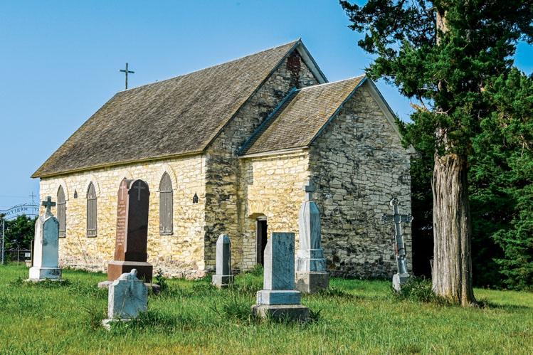 |
| The Lakeport Church in rural Yankton County dates to 1884. |
Chalkstone Church
We drove 8 miles west of Yankton on Highway 50 to 431st Avenue, then turned right to the Bruce and Donna Schwarz farm. Drive slowly through the farmyard — the Schwarzes don’t mind — and you come to a small church built of the yellow chalkstone found along stretches of the nearby Missouri. Neighbors keep up the church and mow the cemetery, which features Czech surnames still common in the area. This is Czech country, settled by pioneers from Bohemia and Moravia who began to arrive in 1869. Their first settlement was Lakeport; only the little yellow church, constructed in 1884, has survived.
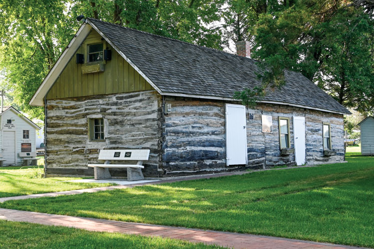 |
| A wooden church is among the historic buildings preserved at the park in Tabor. |
TABOR: CZECH CAPITAL
A few miles further along Highway 50 is the town of Tabor (pop. 405), founded in 1872. Tabor is famous for its annual Czech Days celebration in June. Parking is more plentiful on the other 362 days of the year, so stop on Main Street and stretch your legs by walking through the quaint pioneer village which includes a tiny wood church that was built at Lakeport even before the chalkstone church. Now it is well-kept in the Czech Preservation Society’s heritage park along with several other antiquated structures.
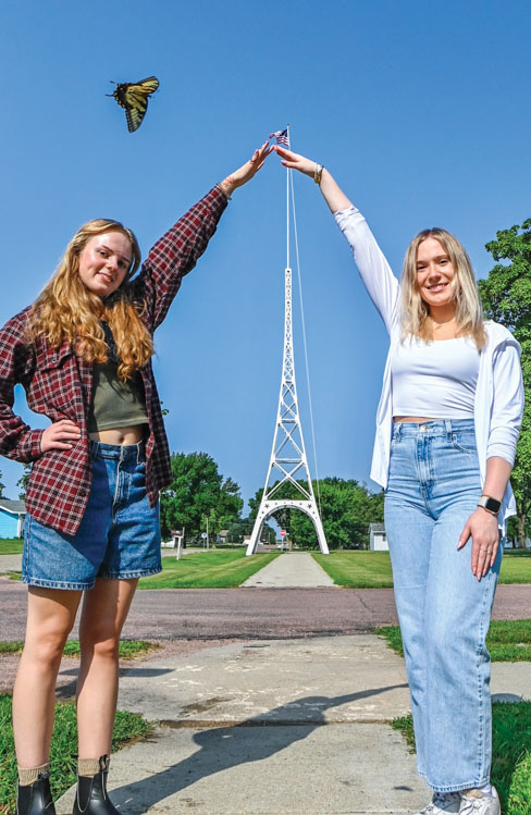 |
| Magazine interns Rose Lane (left) and Ava Brandt at Tyndall's Eiffel Tower, a fancy flagpole that measures 100 feet. |
TYNDALL’S TOWER
One wonders if Gustave Eiffel, engineer and namesake of the tallest structure in Paris, would be flattered to see the imitation in Tyndall.
Tyndall’s “Eiffel” is more than 1,000 feet shorter than Gustave’s, but nearly as old. It was constructed in 1898, just nine years after the original was completed to honor the centennial of the French revolution.
The replica stands on the lawn of the county courthouse, west of downtown on 18th Avenue. But before you visit the tower, stop at the Radack family’s bakery. We dilly-dallied too long, and the cases were nearly empty, so we missed out on the Tyndall Roll, a Bismarck-like pastry filled with white cream and topped with crushed peanuts. No one knows when the legendary roll was created, but the bakery traces its history to 1905.
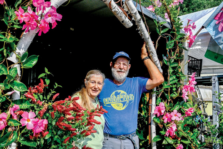 |
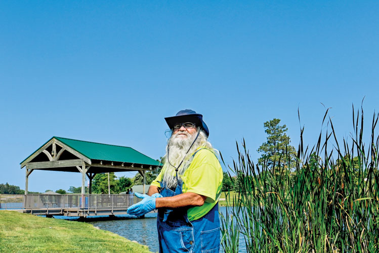
| Carol and Vern Tolsma at their Avon greenhouse. |
AVON’S GREENHOUSE
Feeling lonely in southeast South Dakota? Just visit Vern and Carol Tolsma’s Mensch Greenhouse and Flower Shop along Highway 50 in Avon.
Carol’s grandmother, Ada Mensch, started the greenhouse in 1957. Imagine how many flowers have bloomed, thanks to Ada, in 67 years. And how many people have enjoyed the garden bounty that took root here.
The flowers and plants come with free advice. Did you know you should only water tomato plants when absolutely necessary? Vern says a thirsty plant sends roots deep into the soil, making it strong and adding taste to the fruit.
Digger, the greenhouse dog, wags and nuzzles anyone who’ll take the time. Cats and cockatiels also share the space. The cockatiels are orphans who lost their owners and found refuge here.
The Tolsmas tend a 2-acre garden near the shop, and they sell produce, canned goods and amazing pickles. They occasionally set out a table of freebies that need a home.
Some days, Vern wears a blue t-shirt that says it all: “I Love Gardening From My Head to My Tomatoes.”
 |
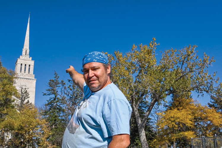
| Richard Langdeaux helps keep Wagner's park looking beautiful. |
A WALK IN THE WAGNER PARK
Follow Highway 50 northwest. South Dakota’s Czech heritage extends into Charles Mix County and the city of Wagner (pop. 1,603), the largest town on this loop tour. Wagner has all the amenities you might want — a coffee shop, restaurants and a grocery store.
On the west side of town, near Highway 50, lies a little lake and park that would be the envy of any city in America. The lake was created when a dam and rock structures were built in the 1930s by WPA workers. Today the park includes two walking bridges, flower gardens, trails and even a small waterfall. This is the best opportunity of the day for a walk.
Richard Langdeaux, a Santa Claus look-alike who was collecting trash in the park, told us that the stone buildings along the lake were once a Scout camp. Artesian springs keep the lake full year-round.
Wagner also offers an impressive museum, operated by the Charles Mix County Historical Society. The collection is known for its Czech exhibits, as well as artifacts from the Yankton Sioux culture that predates the pioneers.
 |
| Michael Rouse helps maintain the ground around Marty's St. Paul Catholic Church. |
MARTY’S AMAZING CHURCH
Drive west of Wagner for 6 miles to 388th Avenue and turn south for another 6 miles to Marty. The one and only enterprise is a boarding school started by the Benedictines in 1924 and now operated by the Yankton Sioux Tribe.
Alongside the school is St. Paul Catholic Church, built by volunteers — Indians and non-Indians — in the early 1940s of Indiana sandstone, mined from a quarry near St. Meinrad Archabbey, which founded St. Paul’s.
The steepled church (167 feet!) is surrounded by tall trees and other structures, so it’s hard to appreciate from afar. Exit your car and walk about the churchyard, where there are statues of Kateri Tekakwitha, the first Native American saint, and St. Theresa, patroness of missions. On most days, the church doors are open; inside, St. Paul’s looks like something you might see in a European city except that the murals, stained glass and other art are rich in Native American themes.
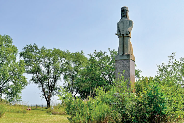 |
| The tallest stone in Greenwood Presbyterian Cemetery marks the grave of Struck by the Ree. |
STRUCK BY THE REE
Follow the road south of Marty for about 7 miles and a few curves. You’ll come to Greenwood Presbyterian Cemetery, where the tallest stone marks the grave of Struck By The Ree, a maligned and misunderstood leader of the Nakota. He was born in 1804, as Lewis and Clark came through the river valley. Legend says the explorers wrapped the baby in an American flag and proclaimed he’d be a great leader.
Struck By The Ree did grow to be a wise chief — an environmentalist, a feminist and a peacemaker. He urged pioneers to preserve the timber resources of the river valley. He pleaded that both Nakota and white men respect the Native women. And though he first fought the intrusion of the white civilization, he eventually recognized that it could not be stopped (“they are like maggots …”). He became a lead negotiator in the 1858 Treaty. Decades later, after the treaty was broken and his people found themselves hungry and hopeless, he was often persecuted; his cabin was burned, and his horses were stolen.
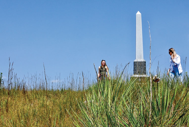 |
| A tall memorial near Greenwood commemorates the 1858 Treaty. |
Treaty Memorial
Continue south and you’ll soon come to another memorial, erected to honor Struck By The Ree and seven other Native American signers of the 1858 Treaty, which gave the government more than 11 million acres for $1.6 million and established a reservation for the Nakota.
The monument was constructed in 1907, topped with an obelisk. A few decades ago, vandals toppled the obelisk — a posthumous insult to Struck By The Ree, a century after his death in 1888. It has since been restored.
 |
| Springfield sits above a growing delta in the Missouri River. |
A MISSOURI RIVER DELTA TOWN
Drive south from the treaty marker and you’ll come to the tiny community of Greenwood, once the hub of the Yankton Sioux Tribe. At Greenwood, if you are not in a hurry, turn right and follow the river for a mile or two for scenic views. Then return and continue east along the Missouri.
Eventually you’ll come to 312th Street, and then to Highway 37 which will lead you to Springfield, once South Dakota’s smallest college town. Thirty years ago, the University of South Dakota/Springfield was closed, despite furious opposition, and the campus was converted to a prison.
Townspeople feared that the prison would be the ruin of Springfield, but it has persevered. Norm’s, once a favorite hangout for collegians, still serves burgers and beer. A company known as Mr. Golf Car parks more than 200 golf carts along Main Street. A museum keeps the history of the college alive, and anglers come to fish the river.
Springfield still has a post office, bank and library — plus several eateries. On its eastern edge is a veteran’s memorial with a panoramic view of the river.
The highway sign lists the population at 834. That doesn’t count the 1,200 prisoners who live there.
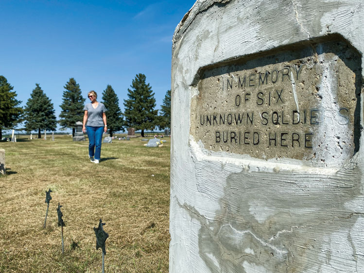 |
| Six unknown soldiers of Lt. Col. George Custer's 7th Cavalry are buried in the Bon Homme Cemetery. |
APPLE TREE ROAD
For a final treat on your loop, turn east onto Apple Tree Road (a mile north of Springfield).
A few miles down the road is a spot known as Apple Tree (though the state Game, Fish and Parks Department calls it Sand Creek). It consists of a campground and cabins, a boat dock and a little peninsula where you can walk out among the reeds and see where the invasive delta ends and Lewis and Clark Lake’s open water begins.
This was once a delightful place to enjoy the bellowing of giant bullfrogs. They were silent on our stop. Perhaps they dislike the phragmites, an invasive wetland plant that is taking over.
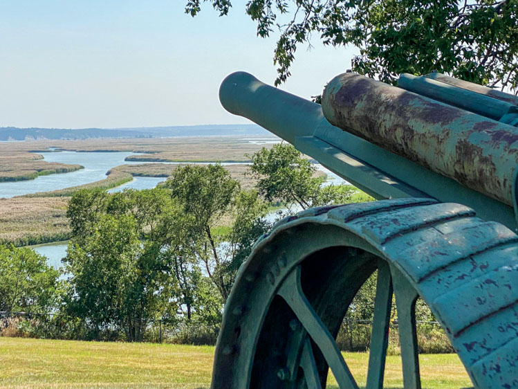
Continue east on Apple Tree Road and you’ll soon pass the tidy Bon Homme Cemetery where a large stone memorial marks the graves of six soldiers who traveled with Lt. Col. George Custer and his 7th Cavalry in 1873.
As Custer’s entourage camped at the nearby town of Bon Homme for four days, six became ill and died. Historians speculate that they contracted typhoid fever. The six were initially entombed at Snatch Creek and then reburied at the cemetery in 1893. In 1922 the large marker was built in the cemetery to give some measure of respect to the nameless six, who might otherwise have perished at the Battle of the Little Bighorn in 1876.
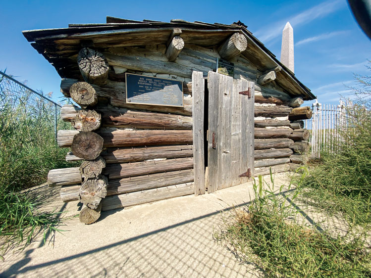 |
| A replica log schoolhouse stands near the Bon Homme townsite. |
BON HOMME WAS A TOWN
Continue south on Apple Tree Road and you soon come to a curve near the old community of Bon Homme. At the curve is a monument to the first schoolhouse in the Dakotas. A small replica of the 1860 log schoolhouse was erected in 1910 by pioneers, and it remains there today. Care to skip a rock in the river (or fish or launch a boat)? Just follow the gravel road south at the curve for less than a mile and you’ll drive right up to the water’s edge and a sandy beach.
Back at the curve, head north to Highway 52. It will lead you east to Highway 50, which takes you past the chalkstone church and on to Yankton.
Editor’s Note: This story is revised from the January/February 2025 issue of South Dakota Magazine. To order a copy or to subscribe, call (800) 456-5117.


Comments